The firm behind Palm Jumeirah designed Dholera's 920 km² master plan.
Halcrow Group was founded in 1868 by Thomas Meik, a British civil engineer who started with river and harbor work in the northeast of England. Over 150 years, the firm grew into one of the world's largest infrastructure consultancies. Their portfolio reads like a list of humanity's most ambitious construction projects: the dredging of Dubai Creek, Port Rashid, Jebel Ali port, the Palm Jumeirah artificial island, and Yas Island in Abu Dhabi. In 2011, Halcrow was acquired by CH2M Hill (now Jacobs), adding American engineering capacity to their existing British and Middle Eastern expertise.
In May 2009, the Gujarat government and DMICDC appointed Halcrow to prepare the master plan for Dholera Special Investment Region. The mandate covered 920 square kilometers, making it one of the largest urban master planning exercises in the world at that time.
Understanding Halcrow's history matters because it tells you the depth of experience behind Dholera's plan. The firm's timeline reads like a history of modern engineering itself:
From 1868 to 1920, operating as Thomas Meik & Sons, the firm built maritime docks, breakwaters, and coastal railways across England. The Hendon Dock and Eyemouth Railway were early landmarks. From 1920 to 1941, as CS Meik & Halcrow, they moved into hydroelectric power and deep tunneling — the Lochaber Hydroelectric scheme and the Ben Nevis Tunnel stretched what was considered possible in mountain engineering.
During World War II (1941 onwards, operating as Sir William Halcrow & Partners), the firm designed the Mulberry Harbours — the temporary portable harbours used during the D-Day landings in Normandy. They also built London's deep-level shelters, which protected civilians during the Blitz. After the war, they designed the London Victoria Line's tunnel infrastructure. From 1998 to 2011, as Halcrow Group, they shifted to coastal reclamation and master-planned islands — Palm Jumeirah, Yas Island, and the High Speed 1 rail link in the UK.
Each era added a new capability. Maritime engineering, tunneling, defense infrastructure, urban transit, coastal reclamation, and finally smart city master planning. By the time Halcrow turned to Dholera, they had solved problems in nearly every domain that a greenfield smart city requires.
Why does Halcrow's Dubai work matter for Dholera? Because the challenges are remarkably similar. Both locations involve flat, arid terrain with harsh climate conditions. Both require large-scale water management. Both demand the construction of entire urban systems from scratch on land where nothing existed before.
Halcrow dredged the entrance to Dubai Creek in the 1950s and 1960s, transforming a pearl-diving town into a trading port. They masterplanned Port Rashid, Dubai's first modern deep-water port. They designed Jebel Ali Port, which remains the world's largest man-made harbor. And they masterplanned Palm Jumeirah — the artificial island that required 90 million cubic meters of sand and rock, engineered with tidal flushing systems through breakwater openings to prevent water stagnation.
The Palm Jumeirah project is particularly relevant. It involved a trunk (mixed-use commercial spine), a crown (17 residential fronds with premium villas), and a crescent (breakwater reef with luxury resorts). Every element had to work as part of an integrated system — water circulation, structural integrity, utility delivery, and transportation. That same systems-thinking approach was applied to Dholera's 920 km² master plan.
The choice was not random. Halcrow had spent decades working on coastal engineering and megastructure projects in the Gulf, where they dealt with similar challenges to what Dholera presents: flat, arid terrain; harsh climate; the need for large-scale water management and desalination; and the requirement to build entire urban systems from scratch. They understood how to plan cities on difficult terrain where nothing existed before. That experience was directly transferable to Dholera's saline, flat landscape on the Gulf of Khambhat.
Specifically, the Gujarat government selected Halcrow for four reasons. First, coastal engineering expertise — Dholera sits near the Gulf of Khambhat, one of the most tidally active coastlines in the world. Second, megastructure master planning — they had already built artificial islands and entire port cities. Third, smart city integration experience — they understood how to layer digital infrastructure onto physical construction. And fourth, a proven track record in challenging environments where other firms would struggle.
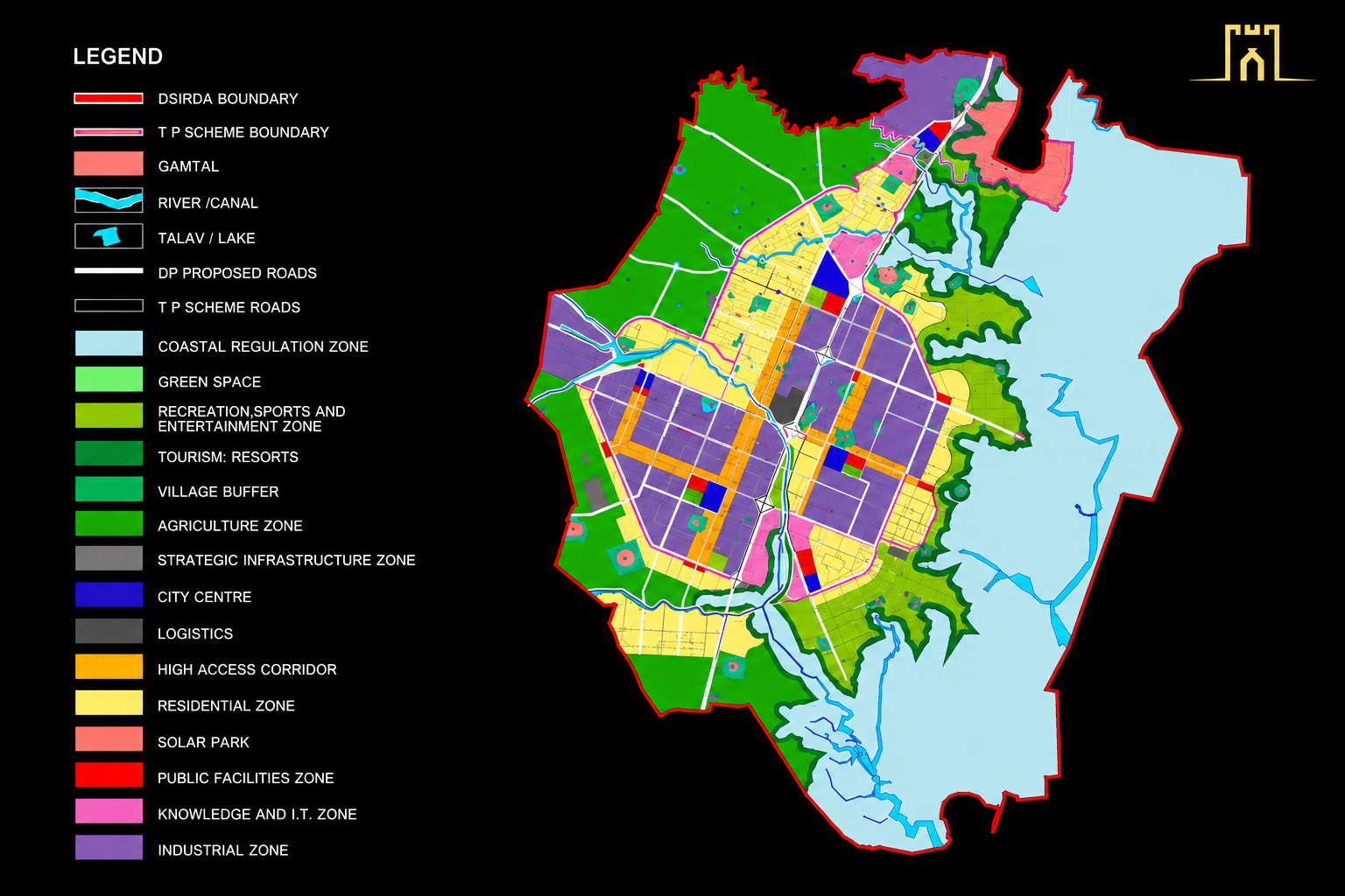
Dholera SIR — 920 km² master plan across 12 functional zones, designed by Halcrow Group
Halcrow structured Dholera around a "Live-Work-Play" concept. The 920 km² area is divided into 12 core functional zones, each with a specific purpose (residential, industrial, commercial, institutional, recreational). These zones are linked by six sub-centers, which act as local service hubs so that residents do not need to travel across the entire city for basic amenities. The zoning is designed to minimize commute times and keep essential services within walking or short transit distance of residential areas.
This is not how most Indian cities are planned. Traditional Indian cities grow organically — residential areas sprout next to industrial zones, commercial districts develop wherever land is cheap, and infrastructure gets built reactively after problems appear. Halcrow's approach is the opposite: every zone has a defined purpose, every utility corridor is pre-planned, and every residential area has guaranteed access to schools, healthcare, parks, and commercial services within its sub-center.
The 12 zones cover the full range of urban needs: residential (multiple density levels), commercial (office and retail), industrial (light and heavy), logistics (warehousing and distribution), institutional (government and education), recreational (parks and sports), and special purpose (airport, port, solar park). No zone exists in isolation. The six sub-centers ensure that daily life — grocery shopping, medical visits, school runs — stays local.
Halcrow did not just design a static blueprint. They created a phased implementation roadmap spanning three decades, with each phase building on the previous one:
Phase I (2012–2022): Activation Area. This phase focused on the 22.54 square kilometer Activation Area — the first section of Dholera to receive full infrastructure. It included 72 km of arterial roads, the ABCD Building (Administrative and Business Center for Dholera), and the underground utility network. The Activation Area is the proof of concept — the section where you can see, touch, and verify that the master plan works in reality.
Phase II (2022–2032): Scaled Expansion. This phase extends infrastructure beyond the Activation Area. It includes the 5,000 MW Solar Park, the Ahmedabad-Dholera Expressway (inaugurated March 2026), and the Dholera International Airport. These are the connectivity and energy projects that transform Dholera from a serviced zone into a connected city.
Phase III (2032–2042): Regional Consolidation. The final phase brings the full 920 km² under development. Metro rail lines, complete industrial build-out, and the full realization of the 12-zone master plan. By 2042, Dholera is intended to function as a complete city — not just an industrial park, but a place where people live, work, raise families, and retire.
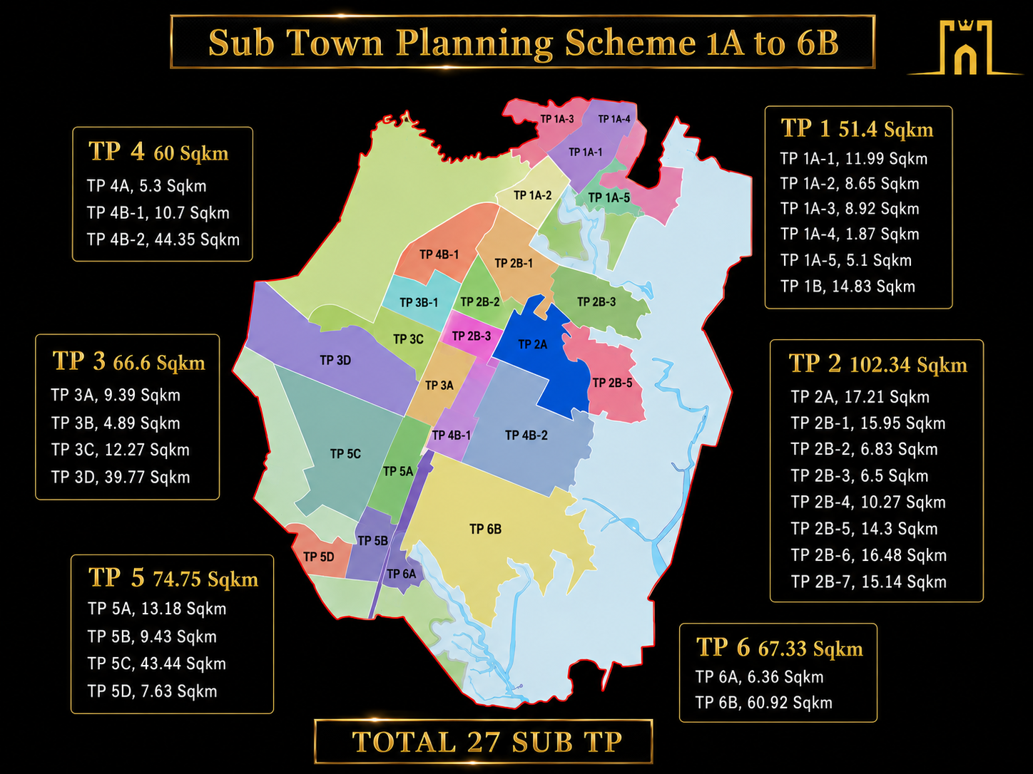
27 Sub Town Planning Schemes — phased implementation across the full 920 km² area
The detailed design and construction supervision was contracted to AECOM, a global infrastructure firm with experience delivering projects at scale. AECOM's role is to translate the master plan into engineering drawings, manage contractors, and ensure that what gets built matches the original design intent. The firm uses Building Information Modeling (BIM) and Geographic Information System (GIS) tools to manage the enormous amount of data involved in planning a city of this size. Every utility line, every road alignment, every plot boundary exists in a digital twin of the city that can be updated as construction progresses.
Think of it this way: Halcrow drew the architect's vision. AECOM is the construction manager making sure every wall goes up where the architect intended. The digital twin means that 20 years from now, when a maintenance crew needs to find a water pipe, they can pull up the exact location, depth, material, and installation date from the system. That level of record-keeping does not exist in any traditional Indian city.
The Dholera master plan is not just about building a city. It is about building an economic engine. The target is for Dholera to contribute up to 50% of Gujarat's GDP over the long term. That is an ambitious number, but it reflects the scale of industrial investment planned for the region: semiconductor fabrication (Tata), renewable energy manufacturing (ReNew), aerospace, data centers, and the supporting ecosystem of suppliers and services that follows anchor industries.
For context, Gujarat's current GDP is approximately ₹18-20 lakh crore. A 50% contribution from one city would mean Dholera's economy rivals many mid-sized countries. Whether that target is hit depends on execution, but the master plan is structured to support that level of economic activity — the zoning, the infrastructure capacity, the transportation links, and the utility systems are all designed for a city of that scale.
When you buy a plot in Dholera, you are not buying into an unproven concept sketched by a local developer. You are buying into a master plan designed by one of the world's most experienced urban planning firms, backed by a construction management team with global project delivery credentials, and governed by a detailed zoning system that has already been approved by the Gujarat government. The planning is done. The infrastructure is being built. Your investment is in the execution phase, not the idea phase.
See how Dholera's 12 zones and 6 sub-centers are laid out across the 920 km² master plan.
Explore the Master Plan →Dholera's phased infrastructure delivery follows a 30-year timeline from Activation Area to full city build-out.
Read the Future Vision 2030–2050 →